
The thing about wintertime in British Columbia is … it’s cold.
As kayakers, we decided to make the trip anyway and surf the Skookumchuck Narrows on the 27th and 28th of December, 2014.
The crew consisted of Leif Anderson, my brother Eli, and me. For some reason, we had difficulty convincing other folks to join us on this wintertime excursion. Excuses were made like “I spend the holidays with my family,” “It will be cold,” and “I think my wife would divorce me.” Whatever.
We hopped in the car and drove north.
Dawn tides required a 5:30 am wake-up, and we paddled to the wave in the dark, our strokes stirring up bioluminescence.
I’ve made four trips to “Skook” over the years, but this was the first in the winter. After one night of sleeping in puddles near the Post Office in Egmont, BC, we broke down and rented a small cabin, but, most importantly, we still had a couple of sick surf sessions.
I’ll let the slideshow below tell the story of how fun those sessions were, but first, here are some tips to planning your own adventure to BC’s wave playboating paradise (at any time of year).
Planning a Session: Tides & Charts
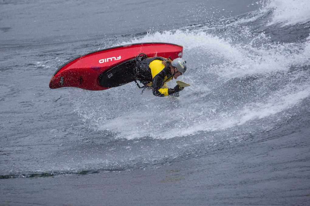
Skookumchuck is unlike pretty much any other wave that kayakers surf. It forms when the tide rushes through a narrow channel in the Sechelt Inlet on BC’s Sunshine Coast. The wave changes continuously throughout each session, as the current gradually speeds up and slows down again. No ride is exactly the same as the wave progresses from slow and small, to big, and back to small over the course of four to five hours.
In order to plan a trip, you need to check tide charts instead of flows. Conveniently, tides are forecasted years in advance, so it’s easy to plan a session at the Skook and know what you’re in for; you won’t need a spur-of-the-moment flood water event to get some good surfing in.
There are several websites where you can view tide charts for the inlet, but this is my favorite. There you can view projected tidal data over whole weeks or months, or see the speed of the tidal current throughout a single day.
What you’re looking for in these charts is a current speed and time with “Max Flood” written next to it. The wave is typically big enough to be surfed during about a four hour window, two hours before and after a given “max flood” time. Fast tidal currents occur at all times of the year, but it’s more likely you’ll be surfing during daylight hours on the wave in the summer, given the longer days.
Current Speeds
I suggest looking for max flood speeds higher than 11 knots.
At 11-12 knots, the current is still rather slow and the wave is relatively small. ~11 knots is perfect for those looking for a mellower surf session, but the wave really starts to swell around 13.5 knots, and I think 13-14.5 knots is the perfect speed for surfing it. With currents at those speeds, the wave is big and steep near its peak, but keeps its foam pile, retentiveness, and doesn’t green out for too long.
This is not an exact science though, and different people have their own preferences. The tide height also plays a factor, so a current of 13 knots will not always produce exactly the same wave.
Faster tides are a blessing and a curse. The wave will begin to green out for extended periods of time when speeds exceed 14 knots, which means that the wave may not be surfable for an hour or more during the cycle. Sometimes, however, the green wave will break and become surfable for a few minutes at a time during these fast tides. When the wave is breaking and it is at its steepest and fastest, that’s the best time to throw bigger tricks.
Speeds above 14 knots have another drawback known as “The Tour,” which I’ll say more about in a moment, and it starts to get mighty intimidating. I always use an overthruster or an implosion resistant skirt when surfing Skook because of the intimidating rapids that form behind the wave.
The Skook has an eddy service during slow tides and at the beginning and end of each tidal cycle. You’ll have to hike it when the tide speeds up. Catching the wave from the eddy gets impossible when the tide is moving fast, but it’s only about 50 meters to walk your boat back to the top and put in for another surf.
And if you’re not an expert play boater, don’t rule Skookumchuck out. The wave is a heck of a lot bigger than what most of us regularly get a chance to play with on rivers, but it certainly isn’t the largest standing wave that kayakers surf. It is also much easier to surf than most waves of a similar size because it is not overly surgy or boiling on the face.
Still, if there’s one thing to be wary of, it’s…
“The Tour”
Skookumchuck isn’t just a wave, it’s a rapid. About 50 meters downstream from the wave, the eddy line expands to massive proportions with boils and whirlpools that will eat you alive. If you don’t make the eddy immediately, prepare to go on a five minute “tour” of the inlet.
It’s really not too bad so long as you don’t fight it. Just relax, stay upright, and focus on avoiding the whirlpools. Once you are at the bottom of the rapid, ride the eddy current all the way back up. Attempting to paddle toward shore across the 100 foot wide boils on the eddy line is often futile and always exhausting.
The Tour doesn’t get too bad until you’re dealing with currents of 13.5 knots or greater, and catching the eddy is easy at slow tidal speeds. But a strong roll is always necessary at Skook.
Once speeds exceed 14 knots, however, you must have a no-questions roll and be comfortable staying upright in a play boat in a huge maelstrom of boils, whirlpools, and crashing waves.
Getting to Egmont
Egmont, BC is the closest town to Skookumchuck. Google maps will give you a good idea of driving directions to Egmont, but there are a few helpful things that I’ve learned over the years about routes and ferries.
If you’re driving north from Seattle, don’t cross the Canadian border at the Peace Arch. Exit I-5 a few miles before the border and cross via Highway 543. Follow Highway 15 North into Canada and then take Highway 1 West directly to the Ferry Terminal. There is a toll bridge on this route, but it is by far the most direct way to get to the ferry and it’s worth a few bucks to avoid Vancouver traffic.
The ferry that you’ll want to take is from Horseshoe Bay to Langdale. The ferry costs $50.95 CAD per vehicle and $15.25 CAD per passenger round trip, and you can find the schedule on the BC Ferries website. Show up at least 30 minutes before your intended sailing, because the ferry tends to be overfilled. Missing a sailing isn’t a huge deal, but you’ll have to wait for the next one, and that adds a lot of time to your drive. Also know that there are fewer sailings on Sundays.
Vancouver is the best airport to use if you’re visiting from further afield. Tides are typically only fast enough for the wave to be surfable for 4-5 days at a time in a given month, so it is best to combine it with some other paddling in Washington or BC if you’re coming from a very long distance.
Getting to the Wave
Put in at the government marina in the town of Egmont, which is the marina to your left when facing the water from town.
From there, paddle out into the channel and turn right. The paddle in goes pretty quickly once you’re in the current, and usually only takes 20-30 minutes, depending on the tide. Stay toward the right side of the channel as you begin to pass a number of islands, and listen for the roar of the rapids. Keep in mind that the current speeds up a lot as you approach the wave.
There are two options for getting to the wave and back each day. My preferred method is to paddle back and forth from town each day. The paddle back to town takes about 40 minutes – just hug the shore and eddy hop your way back up the channel. The current isn’t usually too strong after the wave dies down, so paddling back isn’t typically too strenuous.
Some folks choose to stash their boats in the woods and hike out each day, only paddling back to town after their last session. From Egmont, the trail to the Skook is a few miles long and takes approximately 40 minutes each way. I think that hiking in/out each day is more time consuming over all.
It’s a good idea to show up to the wave approximately two hours before the “max flood” time you’re trying to hit, and plan to stay for two hours after to get a full session of surfing in.
NEXT: Where to Stay, a Note on Gear, and Our Photo gallery…
Nice report! Do you ever see any paddle boarders or surfers out there? It looks like it would be an epic SUP wave, but the swim sounds horrible.
Benjamin,
I have seen video of paddle boarders and surfers out there. This video has some shots of a SUP on Skook around 9 minutes in: http://vimeo.com/72680200. The filmmakers might have some good input about SUPing the wave.
I think it would be a good idea to try it out at relatively slow tides (like 11 knots to 12.5 knots) before hopping out there at really fast tides. At those slower speeds, the swim would probably not be too terrible with the combined flotation of a wetsuit, PFD, and your board.
And remember, even on days with really fast tidal speeds, the tide will be slow at the beginning and end of the flood cycle. I’d say definitely get out there and try it!
Good luck!
David
David & Paddle Pals,
Thank you for sharing great eyecandy pics, thorough directions north (plus the cut off using Highway 543 + +) as I will be starting trip from Portland, the exciting Tour info, plus the area tidbits.
Paddle Safe/Happy
Chris